The review period is open, and residents can view the Environmental Assessment Worksheet (EAW)for the proposed 511-unit Walden at Hastings development planned for 71.1 acres off of Hwy. 316 and …
This item is available in full to subscribers.
To continue reading, you will need to either log in, using the login form, below, or purchase a new subscription.
If you are a current print subscriber, you can set up a free website account and connect your subscription to it by clicking here.
Otherwise, click here to view your options for subscribing.
Please log in to continue |


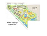
The review period is open, and residents can view the Environmental Assessment Worksheet (EAW)for the proposed 511-unit Walden at Hastings development planned for 71.1 acres off of Hwy. 316 and Michael Avenue.
The report can be viewed at: https://www.hastingsmn.gov/city-government/city-charter-ordinances/legal-notices on the City of Hastings website, according to a public notice published by the city in the Dec. 7 Hastings Journal. The public review period of the EAW, which includes a traffic study conducted in the development area, terminates Jan. 11, 2024. City Community Development Director John Hinzman said comments on the EAW can be submitted to him.
A public hearing will be held before the Hastings City Council on Feb. 5 to review comments EAW comments.
Walden at Hastings development is slated to start next year. It is being developed by LandEquity, LLC. Councilmember Lisa Leifeld said at the Dec. 4 city council meeting she has heard concern of a prime piece of agricultural land being sacrificed for the development.
The property has been owned by Best Development for more than 25 years, which has leased the site for agricultural purposes.
Under the Walden at Hastings plan, 17.5 acres that are the Sand Coulee would remain as a nature preserve, and the developer is seeking to work with the Minnesota Department of Natural Resources to take ownership of that.
Walden at Hastings is planned as “life-cycle housing,” meaning housing for every stage of life. The development would have trails and park-like amenities, according to plans. The environmental study states, “The project aims to incorporate family living in one development. Whether a person is owning their first, having their second child, living their active lives in their senior years or needs assistance and care, they are welcome. The goal is to have families living and thriving in the same development.”
Proposed are 54 twin homes, 68 town homes, 170 apartments, assisted living unit complexes of 24 and 80 units and 60 active senior living units. In 2029, plans are for construction to start on 55 single family homes.
LandEquity plans for the development to be all rental units, with rents in the neighborhood of $2,000-$4,000 monthly.
The city approved annexation of the land into the city in the spring. The council approved moving the EAW for public comment last week.
“What the Environmental Assessment Worksheet does is provide an assessment of that (the proposed development). This is something that was put together by the developer’s engineer and reviewed by city staff with tweaks made, and we’ve brought this forward to you for action tonight,” Hinzman told councilmembers. “Now what will happen in the future upon your authorization, this will be distributed to a number of different agencies and will also be available for public review as well. The public will be able to comment on this and state agencies and federal agencies are obligated to be provided this document for their comment as well.”
Prior to the public hearing, Hinzman said comments will be viewed.
“The determination that we’ll need to make at that point is whether the EAW is adequate and whether any other environmental investigation is necessary,” Hinzman said. “If it turns out that there were other questions and potentially more environmental assessment necessary, we would take action at that point.”
If there are not problems, work likely would commence as soon as city permits, and approvals are granted.
“Assuming the EAW is adequate after public review, the developer would be submitting his land use applications for action, his plat, his site plan, the nuts and bolts of what we’ve been seeing beyond the concept plan. The developer is anticipating that over the winter, so towards spring, if things go well on that, perhaps we’d see some dirt turning later on this year.”
Leifeld questioned when the land was included as a residential development in the city Comprehensive Plan.
“I’ve had a few conversations with a resident, and I just was hoping you might be able to clarify how this overall process works when we’re dealing with land on the south of town, obviously exceptional farmland. A farmer or whoever owned this property. How did we get from a farmer owning the property to where we are today?” she asked.
Hinzman said the land has been earmarked for residential development for at least 20 years.
“Our Comprehensive Plan will designate property for future development. That doesn’t obligate someone to develop but provides them the opportunity for development of occur. The land that is part of this EAW was identified within our Comprehensive Plan for future development. There was a residential density that was established on that property, and now that developer is coming back with this plan. Really, it’s a decision for the owner of the property to make if it’s within our Comprehensive Plan.”
Hinzman said improvements to Hwy. 316 the last few years made development like this easier to consider.
Leifeld commented, “Development is important, right, to our community. We’re a bit landlocked in regard to the rivers that surround us. Ultimately knowing that it an owner’s right to do what they wish with the land and understanding that this wasn’t something that they were strong-armed into or anything along those lines.
“I know farming has a long history in our community. We certainly want to be able to promote that farming around us.”